


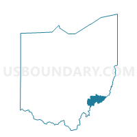
WATERFORD A Voting District, Washington County, Ohio
About
Outline

Summary
| Unique Area Identifier | 653152 |
| Name | WATERFORD A Voting District |
| County | Washington County |
| State | Ohio |
| Area (square miles) | 26.95 |
| Land Area (square miles) | 25.92 |
| Water Area (square miles) | 1.03 |
| % of Land Area | 96.16 |
| % of Water Area | 3.84 |
| Latitude of the Internal Point | 39.53944130 |
| Longtitude of the Internal Point | -81.65833210 |
Maps


Graphs
Select a template below for downloading or customizing gragh for WATERFORD A Voting District, Washington County, Ohio


Neighbors
Neighoring Voting District (by Name) Neighboring Voting District on the Map
- ADAMS Voting District, Washington County, OH
- BEVERLY Voting District, Washington County, OH
- PRECINCT CENTER TOWNSHIP, Morgan County, OH
- PRECINCT STOCKPORT/WINDSOR, Morgan County, OH
- WATERFORD B Voting District, Washington County, OH
- WATERTOWN Voting District, Washington County, OH
Top 10 Neighboring County Subdivision (by Population) Neighboring County Subdivision on the Map
- Waterford township, Washington County, OH (3,713)
- Windsor township, Morgan County, OH (2,089)
- Adams township, Washington County, OH (1,617)
- Watertown township, Washington County, OH (1,579)
- Center township, Morgan County, OH (743)
Top 10 Neighboring Place (by Population) Neighboring Place on the Map
Top 10 Neighboring Unified School District (by Population) Neighboring Unified School District on the Map
- Morgan Local School District, OH (14,178)
- Fort Frye Local School District, OH (6,337)
- Wolf Creek Local School District, OH (3,473)
Top 10 Neighboring State Legislative District Lower Chamber (by Population) Neighboring State Legislative District Lower Chamber on the Map
Top 10 Neighboring State Legislative District Upper Chamber (by Population) Neighboring State Legislative District Upper Chamber on the Map
Top 10 Neighboring 111th Congressional District (by Population) Neighboring 111th Congressional District on the Map
Top 10 Neighboring Census Tract (by Population) Neighboring Census Tract on the Map
- Census Tract 213, Washington County, OH (5,111)
- Census Tract 216, Washington County, OH (3,707)
- Census Tract 9691, Morgan County, OH (3,480)
- Census Tract 9688, Morgan County, OH (3,296)